By Kristina Pydynowski, AccuWeather senior meteorologist
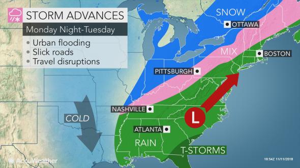
AccuWeather-(ENEWSPF)- A new storm with rain, snow and travel disruptions is taking aim at the midwestern and northeastern United States early this week with another storm on its heels.
The same storm pushing snow into Oklahoma and northern Texas into Mondaywill cause snow to streak across the lower Midwest states and into the interior Northeast. The I-95 cities will once again face a soaking rain.
The snow is projected to sweep from St. Louis to Detroit, Cleveland and Buffalo Monday through Monday night.
“Snowfall amounts will be just enough to cause some travel problems,” according to AccuWeather Meteorologist Brian Thompson. Between a coating to two inches of snow is expected in many of these areas.
The snow may initially melt on sidewalks and roads, but slippery conditions can eventually develop as the snow falls late in the day and night and as temperatures drop below freezing.
For those working on Veterans Day in St. Louis, it could be a slick drive home with flight delays on Monday evening.
“The timing of the snow could create a slippery Tuesday morning commute around Detroit and Buffalo,” Thompson said.
The interior Northeast is anticipated to see the return of snow Monday night through Tuesday.
While there can be a period of slick conditions, the snow mixing with or changing to rain should prevent this storm from causing major issues from Pittsburgh to Binghamton and Albany, New York, and in Burlington, Vermont.
The most persistent snow and travel hazards await northern Maine and neighboring parts of Canada (including Quebec City), where 4-8 inches can fall.

Another rainstorm for the Northeast’s I-95 corridor
The track of the storm is expected to bring another round of soaking rain from Richmond, Virginia, to Philadelphia, New York City and Boston Monday night into Tuesday.
“Rainfall in most areas will be between 0.75 of an inch and 1.25 inches, which can cause flooding of streets and poor drainage areas because of how hard the rain could come down for a time,” Thompson said.
Residents and property owners will want to ensure that leaves are not clogging storm drains prior to the rain.
Even in the absence of flooding, the downpours will reduce visibility for motorists and heighten the risk of vehicles hydroplaning when traveling at highway speeds. Wet leaves can make roads and sidewalks slippery.

“The heaviest rain will fall during the overnight hours of Monday from Philadelphia to New York City, which can lead to street flooding that impacts the Tuesday morning commute,” Thompson said.
Commuters around Boston will also have to deal with increasingly heavy rain on Tuesday morning.
Airline passengers throughout the I-95 corridor in the Northeast may face delays on Tuesday due to the rain and/or low-hanging clouds.
“The fast-moving nature of this storm will limit any coastal flooding issues to a few hours on the front side of the storm,” according to AccuWeather Senior Meteorologist Alex Sosnowski.
Download the free AccuWeather app to know how much rain or snow is headed to your community.
More cold to invade the entire Northeast
Much like recent storms, the I-95 corridor will escape snow but not the cold plunging in on the storm’s backside.
Temperatures rising into the 50s from Washington, D.C., to Boston on Tuesday are expected to be replaced by highs in the 30s and lower 40s on Wednesday. Brisk winds will create even lower AccuWeather RealFeel® Temperatures.
As the cold air rushes in behind the storm, any rain can change back to snow showers over the Appalachian Mountains by the end of Tuesday.
Lake-effect snow will re-develop from west to east downwind of the Great Lakes.
Another storm on the horizon for late week
Outside of the lake-effect snow, the rest of the Northeast will be dry on Wednesday. As has been the theme since the summer, the dry period will not last long. Another and potentially more impactful storm is aiming for the eastern United States late this week.
The storm can be complex and far-reaching with wintry weather spreading over a portion of the Midwest as windswept rain once again soaks the Northeast coast.
There can be an extended period of snow or an icy mix during the storm across the interior Northeast and southern Appalachians.
There can be a period of wintry weather much closer to New York City, Boston and Portland, Maine, than during recent storms.


