


Past 12 months and first third of the year were warmest nation has experienced
Washington, DC–(ENEWSPF)–May 9, 2012. Several warm periods across the contiguous U.S. during April brought the national average temperature to 55°F, 3.6°F above average, marking the third warmest April on record. These temperatures, when added with the first quarter and previous 11 months, calculate to the warmest year-to-date and 12-month periods since recordkeeping began in 1895.
The 12-month period of May 2011-April 2012 has a nationally-averaged temperature 2.8°F above the 1901-2000 long-term average, while the January-April 2012 months were 45.4°F, 5.4°F above the long-term average.
On the heels of the warmest March for the U.S., warmer and drier than average temperatures continued for much of the nation with some states in the Ohio Valley having a small, but still above average, dip in temperatures.
Note: The April 2012 Monthly Climate Report for the United States has several pages of supplemental information and data regarding the unprecedented early 2012 temperatures.
U.S. climate highlights — April
- Warmer-than-average temperatures were present for a large portion of the nation during April with nine states in the Central and Northeast regions having April temperatures ranking among their ten warmest. Above-average temperatures were also present for the Southeast, Upper Midwest and much of the West.
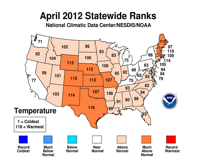
 April 2012 Statewide Temperature (top) and Precipitation (bottom) ranks
 - Eight states — Illinois, Indiana, Kentucky, Michigan, Wisconsin, Ohio, Pennsylvania, and West Virginia — had average April temperatures cooler than their March temperatures. However, these temperatures were still above the long-term average for the month.
- Statewide precipitation totals were mixed during April, with wetter than average conditions across the West Coast and Northern and Central Plains. Drier than average conditions were present in Texas and along the Gulf Coast, stretching northward toward the Great Lakes. The national precipitation average was 2.23 inches, 0.20 inch below average.
- According to the Rutgers Global Snow Lab, the April snow cover extent across the contiguous United States was the third smallest on record, despite the late season Nor’easter which impacted the Northeast with snow near the end of April.
- According to NOAA’s Storm Prediction Center, there were 228 preliminary tornado reports during April, above the 1991-2010 average for the month. The majority of the tornadoes occurred during an April 14th outbreak across the Central Plains. Tornado activity during April 2012 was in stark contrast to April 2011, when over 750 tornadoes tore across the Southeast, causing significant damage and loss of life.
U.S. climate highlights — Year-to-date
- January-April was the warmest such period on record for the contiguous United States, with an average temperature of 45.4°F, 5.4°F above the long-term average. Twenty-six states, all east of the Rockies, were record warm for the four-month period and an additional 17 states had temperatures for the period among their ten warmest.

Year to Date “Horserace” Graphic for Des Moines, Iowa’s average temperature to date. For a more complete listing of major cities which have experienced their warmest Jan-Apr, please click for supplemental information.
- The first four months of 2012 were drier than average for the contiguous United States as a whole, with some regional variability. The eastern third of the nation was drier than average, with Maryland and Delaware record dry, and an additional six states had precipitation totals ranking among the ten driest. Drier than average conditions were also present for much of the Interior West.
- Wetter than average conditions occurred across the central regions of the country and the Pacific Northwest, where above average precipitation contributed to higher than normal mountain snowpack at the end of the snow season. The amount of snowpack in the springtime is important in determining water supply for the region for the upcoming summer period.
- According to the U.S. Drought Monitor, as of May 1st, 38.2 percent of the contiguous United States was experiencing drought conditions, an increase from the 31.9 percent at the beginning of 2012. Drought worsened across the Northeast, Southeast, and the Interior West while beneficial precipitation significantly improved drought conditions across the Southern Plains and western Gulf of Mexico.
- The U.S. Climate Extremes Index (USCEI), an index that tracks the highest and lowest 10 percent of extremes in temperature, precipitation, drought and tropical cyclones across the contiguous U.S., was a record 42 percent during the January-April period, over twice the average value. Extremes in warm daytime temperatures (82 percent) and warm nighttime temperatures (68 percent) covered a large area of the nation, contributing to the record high value.
12-month period (May 2011 – April 2012)

The ten warmest 12-month periods of the U.S. record. Click to enlarge, or click here for expanded information.
- The 12 month period beginning May 2011 through April 2012, which includes several warm episodes for the country — second hottest summer, fourth warmest winter, and warmest March — was the warmest consecutive May-April year-long period for the contiguous United States. Twenty-two states were record warm for the 12-month period and an additional 19 states were top ten warm. The 12-month running average temperature for the contiguous U.S. was 55.7°F, 2.8°F above the 20th century average.
Source: noaa.gov


