By Alex Sosnowski
Senior Meteorologist for AccuWeather
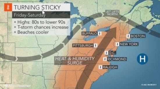
AccuWeather-(ENEWSPF)- AccuWeather reports weather more appropriate for early July will return to the eastern United States through Independence Day.
Steamy air that has been suppressed to near the Gulf of Mexico coast will spread northward into this weekend.
“People in much of the East will be turning up their air conditioners and fans to help cope with the return of the steamy air following cool and refreshing conditions of late,” according to AccuWeather Senior Meteorologist Kristina Pydynowski.
Swimming pools over the interior Northeast will again be busy with activity.
The first phase of the turnaround will be a strong warming trend that will replace highs in the 70s F to middle 80s with highs in the middle 80s to the lower to middle 90s into Friday.
The second phase will be a day-to-day uptick in humidity levels, which will bolster AccuWeather RealFeel® Temperatures.
By Saturday, RealFeel Temperatures will approach the 100-degree mark during the afternoons in the urban areas when factoring in actual temperatures, sunshine, winds and humidity.
However, while the humidity will reach typical levels for the middle of the summer in the South and along the mid-Atlantic coast, it will only be near the oppressive mark for a brief time in much of the Midwest and interior Northeast.
This brevity in some areas will be thanks to a push of slightly less humid air that is projected to reach across the Midwest on Sunday and New England byMonday.
Meanwhile, the Deep South and coastal mid-Atlantic will stay locked in the steamy air, while a little break is likely for the southern Appalachians and Piedmont.
Along with the uptick in humidity will be the likelihood of widely separated thunderstorms in the South. The greatest chance of a thunderstorm downpour in Dixie will be from the mid-afternoon to the early evening hours each day into the weekend.
Farther north, two main rounds of storms are likely with scattered activity in between.
One round of heavy, gusty storms will progress from the Midwest and eastern Great Lakes on Thursday to the Northeast coastal areas on Friday. A second round of storms will advance from from the Midwest on Friday night andSaturday to the coastal Northeast on Sunday.
The return of summery conditions will follow an outbreak of temperatures and humidity levels that were just about as low as can be for this time of the year.
Temperatures dipped into the 40s and lower 50s over the countryside of the Midwest and Appalachians during Monday night and Tuesday night.
“A handful of amateur observers over the central and southern Appalachians had lows in the 30s Wednesday morning,” according to AccuWeather Meteorologist Jesse Ferrell.
Temperatures in many of the major cities from Atlanta to New York City dipped into the lower 60s.
A few locations tied record low temperatures on Wednesday morning set as far back as the 1960s. Meanwhile, Bristol, Tennessee, broke a record low of 50 set in 1970 with a 49-degree reading.


