


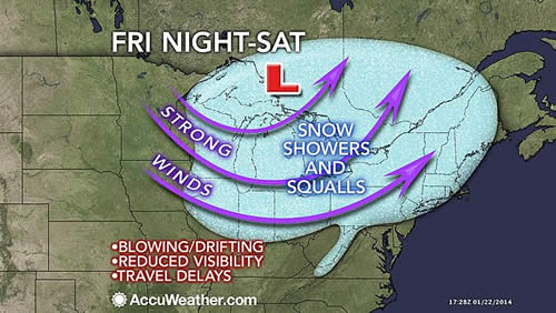
AccuWeather.com-(ENEWSPF)- AccuWeather.com reports a strong Alberta Clipper storm will swing across the Great Lakes region on Fridaynight and Saturday with strong winds, areas of flurries, snow and local blizzard conditions.
The storm has the potential to bring dangerous conditions on the highways including I-65, I-69, I-75, I-79. I-80/90, I-94, I-196 and Route 219. Flight delays are possible at Minneapolis, Chicago, Milwaukee, Detroit, Cleveland, Pittsburgh and Buffalo, N.Y.
After a small and weak clipper storm swings through Thursday into Thursday night, a larger and stronger clipper storm will drop in on Friday.
The stronger storm will ride a reinforcing blast of bitterly cold air that will slash temperatures by 10 to 20 degrees this weekend, preceded by a modest rebound.
The powerful circulation around the storm will bring wind gusts to 50 mph in some locations.
According to AccuWeather.com Senior Meteorologist John Gresiak, "The combination of rounds of dry, powdery snow, gusty winds and low temperatures can make for whiteouts and brief blizzard conditions."
Several inches of snow may fall from the storm as it moves eastward Friday night into Saturday night.
RealFeel® temperatures will plunge well below zero as the storm approaches and moves by. In the wake of the storm, actual temperatures will be in the single digits around Chicago and Minneapolis and the teens over much of the northern Ohio Valley states and the Lower Peninsula of Michigan.
Lake effect can enhance snowfall rates in localized areas. Since some of the lakes still have large stretches that are free of ice, bands of heavy lake-effect snow are possible just ahead of the system on southwest winds and behind the system on northwest winds.
"In areas where the lakes are frozen, the smooth, flat surface will be a source for the high winds to send snowdrifts ashore," Gresiak stated.
Some snow and slippery travel will reach as far south as the Ohio Valley and the Appalachians.
Most of the snow with the storm will be screened out by the central and northern Appalachians. As a result, spotty snow showers are forecast to reach areas east of the mountains, along the I-95 corridor Saturday into Sunday. However, a few areas from Pennsylvania and New Jersey northward to southern New England could get a coating of to an inch of snow on Saturday.
The storm will make for blustery conditions throughout the Northeast this weekend and will push much colder air back into the region Sunday, after a brief temperature spike on Saturday.
Another clipper storm on Monday could bring a similar outcome to that of the storm this past Tuesday, such as producing a zone of heavy snow from the Ohio Valley to the central Appalachians and coastal Northeast.
Prior to the strong clipper storm on Saturday, a weak clipper will swing through on Thursday with mainly light snow and slippery travel from the eastern Great Lakes to the central Appalachians.


