


AccuWeather.com-(ENEWSPF)- AccuWeather.com reports the polar vortex will get stronger and move farther south later in January, causing cold to intensify in the Midwest and East and drought to build in California and the West.
As the pattern responsible for rounds of nuisance snow and waves of cold air continues into next week, indications are that bitterly cold air will return later in the month courtesy of the polar vortex.
There is the chance the cold may rival that of early January in some areas.
Impact from the new surge of very cold air may include the already familiar risks from below-zero temperatures including life-threatening conditions and frostbite. The cold may be intense enough to cause school closings, frozen pipes and water main breaks. Heating systems may struggle to keep up, people will spend more money keeping their homes and businesses warm and ice will again build up on area rivers. Where the cold is accompanied by snow, travel delays are likely.
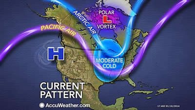
A piece of the polar vortex will continue to hover around Hudson Bay and northern Quebec, Canada, into next week.
In this position, the vortex will continue to act like a giant pinwheel producing a series of weak storms with spotty snow and flurries, as well as brief waves of moderately cold air over southern Canada and the North Central and Eastern United States.
However, during the third and fourth weeks of January, some changes will take place. The high amplitude pattern is forecast to get more extreme. The polar vortex will move farther south and get stronger. The pattern will gradually change the current mixture of Pacific and Arctic air in the Canada Prairies and the North Central U.S. to all Arctic air. The air will get significantly colder over the Canada Prairies and the much of the eastern half of the nation as a result.
West Impact
Storms from the Pacific Ocean will be blocked from rolling onshore along the West coast.
Warmth in much of the West now will continue, with virtually no chance of rain and probably no snow for the Sierra Nevada in California. Above-average warmth in Alaska will likely get more extreme.
Air stagnation and fog may become more of a problem in parts of the West. The risk of wildfires will continue and may get worse. The drought will worsen.

East Impact
The pattern has the potential to produce days of near- to below-zero cold from the northern Plains to parts of the Midwest, more lasting cold in the Northeast and noteworthy episodes of cold over the interior South.
Since the path of the bitterly cold air will be first directed over the North Central states, the cold will not be quite as severe by the time it reaches the Northeast, similar to that of early January.
Prior to and during the main push of the coldest air later in the month in the East, there may be a large storm or two.
According to Senior Meteorologist Bernie Rayno, "We could have a storm slice out of the South Central states and into the mid-Atlantic and Northeast that puts down snow."
Any deep snow cover that occurs could make the cold more severe. Deep snow acts as an insulator to the warming effects of the ground.
"If there is no big snow ahead of the cold in the East, it may take more of the extreme out of the cold," Senior Meteorologist Henry Margusity explained.
The new invasion of frigid air will produce lake-effect snow downwind of areas of open water. While much of Lake Erie has frozen over, most of the other Great Lakes are still open. Some areas immediately downwind of Lake Erie may get colder with this outbreak, compared to the last as a result.
If it is any comfort, during the frigid weather forecast, the daylight will be a bit longer, when compared to just past New Year’s Day. However, the few extra minutes of daylight will have minimal effect on the air mass that could rival the early January visit from the polar vortex.
By ALex Sosnowski, Expert Senior Meteorologist for AccuWeather.com


