By Courtney Spamer, AccuWeather meteorologist
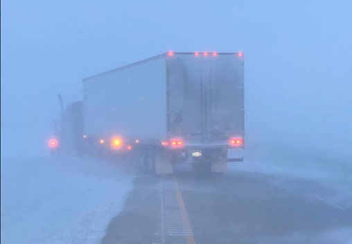
AccuWeather-(ENEWSPF)- A storm that is unleashing flooding rains in the already soggy Southern states collided with the coldest air of the season on its northern side Wednesday, triggering a major snowstorm that brought whiteout conditions across portions of the Plains.
As the system soaking the South moved northward along the Ohio River Valley on Wednesday, cold air typical of February was in place across the central Plains and the Ohio Valley — and there was enough cold air to allow snow to mix in across several states.
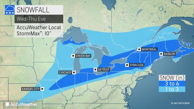
Through the life of the storm, wintry precipitation could potentially impact a 1,500-mile stretch from eastern Kansas to eastern Maine from Wednesday through Thursday.
Blizzard warnings and wind chill advisories were in effect across the eastern Dakotas and southwestern Minnesota early Wednesday.
The storm unleashed more than a foot of snow across higher elevations in Colorado and New Mexico and 3-5 inches in the Texas Panhandle, snarling travel across parts of the region before moving on to the east. Snow totals of up to 3 inches have already been reported across central and eastern Kansas, according to the National Weather Service (NWS).

The brunt of the storm was focusing on areas farther north, where winds whipped up blizzard conditions across portions of the Dakotas. “Near impossible” travel conditions were reported across parts of North Dakota Wednesday morning, according to the NWS as blizzard conditions produced near zero visibility and shut down a stretch of Interstate 29 from Fargo to the Canadian border.
Do not travel advisories were in effect across parts of eastern North Dakota as well as eastern South Dakota.
The North Dakota Highway Patrol said plows were unable to clear the roads due to the limited visibility. In some cases, vehicles lost sight of the road and had driven into a ditch along I-29.
“Conditions are dangerous,” the Highway Patrol said. The agency shared a video of blizzard conditions around Fargo, with worse conditions reportedly outside of the town.
Minnesota State Patrol Public Information Officer Sgt. Jesse Grabow said troopers had responded to several vehicles that had driven off the road including several jackknifed tractor-trailers in west-central and northwestern Minnesota.
Travel was not advised in the northwestern part of the state and stretches of several roadways including U.S. Highway 2 and State Highway 200 were forced to close.
Even though blizzard conditions are not anticipated farther south and east, snow accumulations of 3-6 inches are expected for Midwest communities just east of Kansas City, Missouri and just north of St. Louis to Chicago, Detroit and Cleveland. But, even in Kansas City, St. Louis and Indianapolis enough snow will fall from the storm to create slippery travel.
Travelers along interstates 35, 55, 57, 88, 90 and 94 may all experience snow-covered roads Wednesday and Wednesday night, and AccuWeather meteorologists warn that drifting snow could cause lingering issues on roadways Thursday as the storm pulls away.


