


(GRAPHIC SUPPLIED)
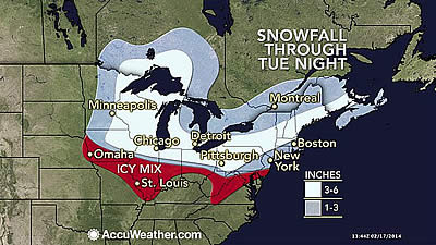
AccuWeather.com-(ENEWSPF)- AccuWeather.com report there will be no rest for the snow weary from the Midwest to East Coast as yet another quick-moving system threatens to lay down a swath of several inches of snow from the Upper Midwest to the Northeast on Mondaythrough Tuesday.
“Even though the storm is forecast to move quickly, it will bring a moderate amount of snow or wintry mix to many communities from the Upper Midwest to the Northeast,” AccuWeather Senior Meteorologist Alex Sosnowski said, “In most cases, the storm will last six hours or less, but a few locations can receive just as many inches of snow.”
An onslaught of winter storms has buried much of the Northeast over the past few weeks. While this upcoming storm is not expected to be an historic event, it can snarl travel, resulting in more flight delays in a winter already full of them.
Residents in Minneapolis will contend with snow-covered roads on Monday, while an icy mix in Des Moines, Iowa, will create slick and hazardous driving conditions.
Winter weather will extend through the Great Lakes and Ohio Valley on Monday, and a surge of milder air should allow precipitation to remain mainly rain south of the Ohio River.
The heaviest snow on Monday is expected to fall in Wisconsin, northern Illinois and Michigan, where some locations may receive a half of a foot. Lengthy travel delays are likely in Chicago, especially during the typically busy late-day commute.
Travel across the region on Monday will be slowed by snow, including I-39, I-75, I-80, I-90 and I-96.
The Northeast will feel the impacts of the storm on Monday night and Tuesday. Shovels and plows will be needed again in many areas.
The quick-hitting snowstorm has the potential to catch motorists by surprise.
“People trying to get home from work or school Monday may get caught in heavy snow or a wintry mix in the eastern end of the Ohio Valley and the western slopes of the Appalachians,” Sosnowski said.
Interstates 76, 80, 81, 90, 95 and 99 will turn slick for a time on Tuesday.
“The same could happen for motorists heading out early on Tuesday in eastern mid-Atlantic,” Sosnowski added.
Flight delays are anticipated for many major hubs including Chicago, Detroit, Boston and the three major airports around New York City.
The snow could once again force administrators to delay or cancel school, adding to the growing list of school cancellations this winter.
The risk of roofs collapsing will increase with each snowfall event, where not enough prior melting has reduced the amount of snow. For example, as ofMonday morning, Feb. 17, 2014, much of Pennsylvania has between 1 and 2 feet of snow on the ground and on roofs.
“In some cases, upcoming melting can add to the risk of roof failure in the short term,” Sosnowski said, “Lingering snow can block the drainage system on flat roofs, leading to uneven weight distribution when melting occurs or when rain falls into the snow.”
Most gable roofs can sustain a significant amount of snow and allow the water to settle toward the edges. However, a buildup of ice in the gutters can force water beneath the shingles along the edges.
Slippery sidewalks will remain a concern as the snow falls, and with cold nights and milder days in the wake of the snow, icy patches will develop. The new snow can hide patches of ice beneath.
For those in search of warmth, a brief break from the snow and cold is in store for the middle and end of the week.
By Dan DePodwin, Meteorologist for AccuWeather.com


