Drought persists, causing water resource issues for central U.S.; 2012 virtually certain to become warmest year on record for the nation
Washington, DC–(ENEWSPF)–December 7, 2012. The average temperature for the contiguous U.S. during November was 44.1°F, 2.1°F above the 20th century average, tying 2004 as the 20th warmest November on record. The autumn contiguous U.S. temperature of 54.7°F was the 21st warmest autumn, 1.1°F above average.
The November nationally-averaged precipitation total of 1.19 inches was 0.93 inch below the long-term average and the 8th driest November on record. The autumn precipitation total for the contiguous U.S. was 5.71 inches, 1.0 inch below average.

Significant climate events for November 2012. Click image to enlarge, or click here for the National Overview.
The January-November period was the warmest first 11 months of any year on record for the contiguous United States, and for the entire year, 2012 will most likely surpass the current record (1998, 54.3°F) as the warmest year for the nation.
Note: The November Monthly Climate Report for the United States has several pages of supplemental information and data regarding some of the exceptional events from the month and season.
U.S. climate highlights: November
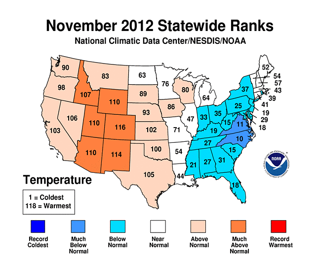
- November brought warmer-than-average conditions to the western half of the country. The largest temperature departures from average were centered near the Rockies where Arizona, Colorado, New Mexico, Utah, and Wyoming had November temperatures among their ten warmest.
- The Eastern Seaboard, Ohio Valley, and Southeast were cooler than average during November. North Carolina tied its 10th coolest November on record, with a statewide-averaged temperature 3.5°F below average.
- A large area of the country experienced below-average precipitation in November. Drier-than-average conditions stretched from the Intermountain West, through the Plains, into the Midwest, and along the entire East Coast. Twenty-two states had monthly precipitation totals ranking among their ten driest.
- According to the November 27 U.S. Drought Monitor report, 62.7 percent of the contiguous U.S. was experiencing moderate-to-exceptional drought, larger than the 60.2 percent observed at the end of October. Drought conditions improved for parts of the Northern Rockies, which were wetter-than-average during November, while conditions worsened for parts of the Southwest and Mid-Atlantic.
U.S. climate highlights: Autumn (September-November)
- Autumn temperatures were above average across much of the western United States. Nevada had its warmest autumn on record, with a seasonal temperature 3.7°F above average. Arizona, California, Idaho, New Mexico, Utah, and Wyoming each had a top ten warm autumn.
- The Ohio Valley and Southeast experienced below-average autumn temperatures. Kentucky autumn temperatures were the sixth coolest while Mississippi had its 10th coolest autumn.
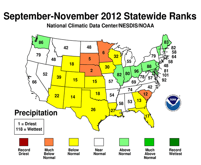
- Autumn precipitation totals were drier than average for the central U.S. and parts of the Southeast. Minnesota, Nebraska, and South Dakota each had a top ten dry autumn. Wetter-than-average conditions were present for the Pacific Northwest, the Ohio Valley, and parts of the Northeast.
U.S. climate highlights: Year-to-Date (January-November)
- The January-November period was the warmest first 11 months of any year on record for the contiguous United States. The national temperature of 57.1°F was 3.3°F above the 20th century average, and 1.0°F above the previous record warm January-November of 1934. During the 11-month period, 18 states were record warm and an additional 24 states were top ten warm.
- It appears virtually certain that 2012 will surpass the current record (1998, 54.3°F) as the warmest year for the nation. December 2012 temperatures would need to be more than 1.0°F colder than the coldest December (1983) for 2012 to not break the record.
- January-November 2012 was the 12th driest such period on record for the contiguous U.S., with a precipitation total 3.08 inches below the long-term average of 26.91 inches.
- Drier-than-average conditions stretched across the central part of the country, from the Rocky Mountains to the East Coast. Colorado, Nebraska, and Wyoming each had their driest year-to-date on record and eight additional states had 11-month precipitation totals among their ten driest.
- Wetter-than-average conditions were present for the Pacific Northwest, the central Gulf Coast, and New England. Washington State experienced its 9th wettest year-to-date.
- The U.S. Climate Extremes Index (USCEI), an index that tracks the highest and lowest 10 percent of extremes in temperature, precipitation, drought and tropical cyclones across the contiguous U.S., was more than twice the average value during the January-November period, and marked the highest USCEI value for the period. Extremes in warm daytime temperatures, warm nighttime temperatures, and the spatial extent of drought conditions contributed to the record high USCEI value.

This graphic shows the calendar-year temperature outcomes based upon observed January-through-November temperatures, and eight historical scenarios for November-through-December. Click here for more information.
Source: noaa.gov


