MARYLAND–(ENEWSPF)–August 24, 2017. The National Hurricane Center has reported that Harvey has been upgraded to a Category 1 (on the Saffir-Simpson scale) hurricane as of 5:00 pm EDT.
NASA Finds Heavy Rainfall in Intensifying Tropical Storm Harvey
NASA examined Harvey as it began to intensify and organize and found heavy rainfall in the system. NASA also created an animation that showed Harvey’s intensification from a low pressure area into a hurricane.
The National Hurricane Center (NHC) upgraded the remnants of tropical storm Harvey to a tropical depression on August 23, 2017 at 11 a.m. EDT (1500 UTC). Harvey became better organized and was revived after moving from Mexico’s Yucatan Peninsula into the Bay of Campeche. The warm waters of the Gulf of Mexico and favorable vertical wind shear promoted the regeneration of the tropical cyclone.
On Aug. 24, NHC noted that Harvey was quickly strengthening and is forecast to be a major Hurricane when it approaches the middle Texas coast. In addition, life-threatening storm surge and freshwater flooding expected.

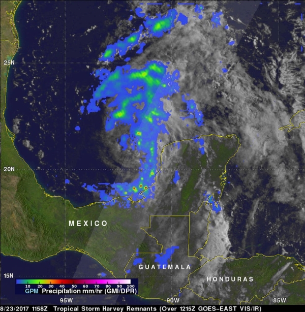
The previous day, NASA provided a look at Harvey’s intensifying rainfall. The Global Precipitation Measurement mission or GPM core observatory satellite flew over the regenerating tropical cyclone on Aug. 23 at 7:58 a.m. EDT (1158 UTC). Data collected by GPM’s Microwave Imager (GMI) and Dual-Frequency Precipitation Radar (DPR) instruments showed that Harvey’s remnants contained areas of moderate to heavy rainfall. A feeder band spiraling in from the southern side of the low contained rain falling at a rate of greater than 1.96 inches (50 mm) per hour. As Harvey intensifies its rainfall capacity can also increase.
GPM’s radar (DPR Ku band) data were used to create the rainfall structure of rainfall within regenerating tropical depression Harvey in 3-D. Those 3-D scans showed that storm tops with the feeder bands in the Bay of Campeche were reaching heights above 8.6 miles (13.9 km). GPM is a joint mission between NASA and the Japan Aerospace Exploration Agency, JAXA.
At NASA’s Goddard Space Flight Center in Greenbelt, Maryland, an animation was created using infrared and visible light data from NOAA’s GOES-East satellite imagery from August 22 to 24. The animation showed the movement of Harvey as a remnant low pressure area moving off the Yucatan Peninsula, re-forming into a tropical depression and now into a hurricane in the southwestern Gulf of Mexico.
NOAA manages the GOES series of satellites, and NASA uses the satellite data to create images and animations. The animation was created by the NASA/NOAA GOES Project at NASA’s Goddard Space Flight Center in Greenbelt, Maryland.
On Aug. 24, many warnings and watches were in effect: A Storm Surge Warning is in effect from Port Mansfield to San Luis Pass Texas. A Storm Surge Watch is in effect from south of Port Mansfield Texas to the mouth of the Rio Grande River and from north of San Luis Pass to High Island, Texas. A Hurricane Warning is in effect from Port Mansfield to Matagorda, Texas. A Tropical Storm Warning is in effect from north of Matagorda to High Island, Texas and south of Port Mansfield, Texas to the Mouth of the Rio Grande. A Hurricane Watch is in effect from south of Port Mansfield, Texas to the Mouth of the Rio Grande. A Tropical Storm Watch is in effect from south of the mouth of the Rio Grande to Boca de Catan, Mexico.
This animation of NOAA’s GOES-East satellite imagery from August 22 to 24 shows movement, and re-intensification of Harvey into a hurricane in the southwestern Gulf of Mexico. TRT: 00:57. Credits: NASA/NOAA GOES Project
The heavy rainfall that the GPM core satellite observed continued to build, and on Aug. 24, the NHC noted that rainfall totals are expected to be tremendous. NHC said “Harvey is expected to produce total rain accumulations of 12 to 20 inches and isolated maximum amounts of 30 inches over the middle and upper Texas coast through next Wednesday. During the same time period Harvey is expected to produce total rain accumulations of 5 to 12 inches in far south Texas and the Texas Hill Country to central Louisiana, with accumulations of less than 5 inches extending into other parts of Texas and the lower Mississippi Valley. Rainfall from Harvey may cause life-threatening flooding.”
At 11 a.m. EDT (1500 UTC), the center of Tropical Storm Harvey was located by an Air Force Reserve Hurricane Hunter aircraft near 24.0 degrees north latitude and 93.3 degrees west longitude. That’s about 365 miles (590 km) southeast of Corpus Christi, Texas.
Data from the Hurricane Hunter plane indicate that maximum sustained winds have increased to near 65 mph (100 km/h) with higher gusts. Rapid strengthening is forecast, and Harvey is expected to become a major hurricane before it reaches the middle Texas coast. The minimum central pressure based on reconnaissance data is 982 millibars.
Harvey was moving toward the north-northwest near 10 mph (17 kph). The NHC forecast noted a turn toward the northwest is expected later today, and Harvey’s forward speed is forecast to slow down during the next couple of days. On the forecast track, Harvey will approach the middle Texas coast on Friday, Aug. 25 and make landfall Friday night or early Saturday, and then stall near the middle Texas coast through the weekend.
For updated forecasts from the NHC, visit: www.nhc.noaa.gov
Source: http://nasa.gov


