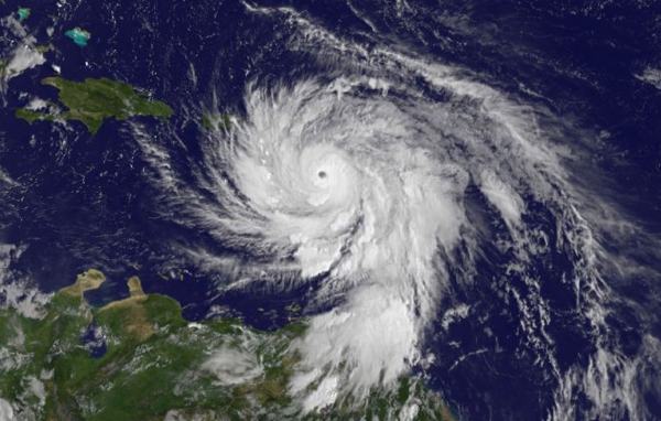
MARYLAND—(ENEWSPF)—September 19, 2017. Satellite data is enabling forecasters to look inside and outside of powerful Hurricane Maria. A NASA animation of satellite imagery shows Hurricane Maria’s first landfall on the island of Dominica. NASA’s GPM satellite provided a 3-D look at the storms within that gave forecasters a clue to Maria strengthening into a Category 5 storm, and NASA’s Aqua satellite gathered temperature data on the frigid cloud tops of the storm.
Maria’s First Landfall
On Monday, Sept. 18 at 9:35 p.m. AST/EDT the National Hurricane Center reported that Maria made landfall on Dominica as a category 5 hurricane. Radar data from Martinique and Air Force Reserve Hurricane Hunter aircraft reports indicated that Maria made landfall on Dominica around 9:15 p.m. AST/EDT (0115 UTC) with estimated winds of 160 mph (260 kph). Dominica is an island in the Caribbean Sea that has mountainous terrain, natural hot springs and tropical rainforests.
NASA Puts Maria’s Past Track in Motion
An animation of NOAA’s GOES East satellite imagery from Sept. 15 at 7:45 a.m. EDT (1145 UTC) to Sept. 19 ending at 4:45 a.m. EDT (0845 UTC) showed Hurricane Jose moving north along the U.S. East coast and Hurricane Maria move through the Leeward Islands and strengthen to a Category 5 hurricane. The animation shows Maria’s landfall in Domenica. The imagery revealed a clear, cloudless eye.
NOAA manages the GOES Series of satellites. The animation was created by the NASA/NOAA GOES Project at NASA’s Goddard Space Flight Center in Greenbelt, Maryland.
NASA’s 3-D Look at Maria

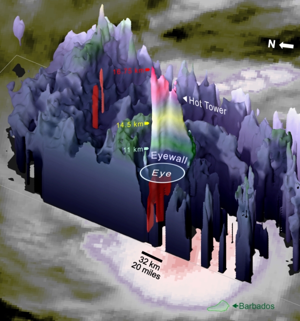
Also at NASA Goddard, a 3-D image of Hurricane Maria was made to understand what was happening within the storm. The dual-frequency radar on the Global Precipitation Measurement (GPM) satellite saw an impressively tall thunderstorms cell of precipitation in the compact eyewall of Hurricane Maria on Monday, Sept.18, 2017. “Enough water vapor was condensing into rain inside of this cell that rapid updrafts developed, rapid enough to lift the precipitation until it froze and then even higher until it penetrated into the lower stratosphere at 16.75 km altitude,” said Owen Kelley of NASA Goddard’s Precipitation Processing System..
“This tall cell (also known as a “hot tower”) was part of a sequence of such cells that were seen by infrared satellite instruments, such as the one on the recently launched GOES-16 satellite. Meanwhile, Maria put on an unexpectedly fast intensification from category 1 to category 3 on the Saffir-Simpson scale on Monday (Sept. 18).”
Research conducted at NASA, at the University of Maryland, Baltimore County, and elsewhere suggests that a sequence of hot towers, also known as a “convective burst,” is one a way to detect that a hurricane’s heat engine going into high gear. The end result is intensified winds circling the eye at the ocean’s surface.
Maria continued to intensify after GPM passed overhead and reached Category 5 status that night.
A Stunning Infrared View of Maria
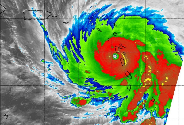
On Sept. 19 at 2:15 a.m. EDT (0615 UTC) the Moderate Resolution Imaging Spectroradiometer or MODIS instrument aboard NASA’s Aqua satellite analyzed Maria’s cloud top temperatures in infrared light.

MODIS found cloud top temperatures of strong thunderstorms in Maria’s eyewall as cold as or colder than minus 80 degrees Fahrenheit (minus 62.2 Celsius). Cloud top temperatures that cold indicate strong storms that have the capability to create heavy rain.
Warnings and Watches in Effect
The National Hurricane Center warned “potentially catastrophic Hurricane Maria continues west-northwestward toward the Virgin Islands and Puerto Rico.”
A Hurricane Warning is in effect for Guadeloupe, Dominica, St. Kitts, Nevis, and Montserrat, the U.S. Virgin Islands, the British Virgin Islands, Puerto Rico, Culebra, and Vieques. A Tropical Storm Warning is in effect for Antigua and Barbuda, Saba and St. Eustatius, St. Maarten, Anguilla and Martinique.
A Hurricane Watch is in effect for Saba and St. Eustatius, St. Maarten, St. Martin and St. Barthelemy, Anguilla, Isla Saona to Puerto Plata.
Maria’s Location and Status on Sept. 19
At 11 a.m. AST/EDT (1500 UTC), the eye of Hurricane Maria was located near 16.3 degrees north latitude and 63.1 degrees west longitude. That’s about 115 miles (180 k) west of Guadeloupe and about 150 miles (240 km) southeast of St. Croix.
Maria was moving toward the west-northwest near 10 mph (17 kph), and this general motion is expected to continue through Wednesday night, Sept. 20. Maximum sustained winds are near 160 mph (260 kph) with higher gusts. Maria is a potentially catastrophic category 5 hurricane on the Saffir-Simpson Hurricane Wind Scale. Some fluctuations in intensity are likely during the next day or two, but Maria is forecast to remain an extremely dangerous category 4 or 5 hurricane until it moves near or over the Virgin Islands and Puerto Rico.
The minimum central pressure based on data from an Air Force Reserve Hurricane Hunter aircraft is 927 millibars.
On the forecast track, the eye of Maria will move over the northeastern Caribbean Sea today, Sept. 19 and then pass near or over the Virgin Islands and Puerto Rico on Wednesday, Sept. 20.
For updates and effects on wind, storm surge and rainfall, visit: www.nhc.noaa.gov.
Source: www.nasa.gov


