By Alex Sosnowski, AccuWeather senior meteorologist
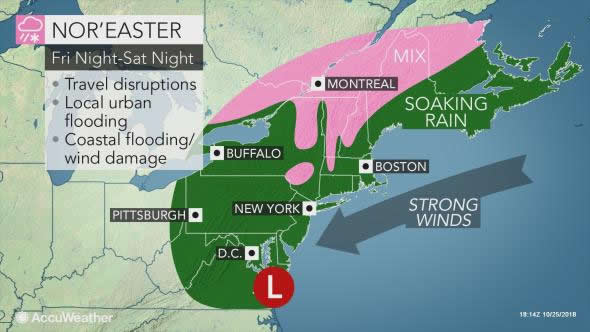
AccuWeather-(ENEWSPF)- A storm from the South will evolve into a potent and disruptive nor’easter with gusty coastal winds, drenching rain and high-elevation snow this weekend.
“Fast forward motion of the storm may limit the worst weather conditions from Friday night to Saturday night,” according to AccuWeather Senior Meteorologist Dave Dombek.
However, that can have quite a miserable and soggy effect on area high school and college football games.
Some of the moisture fueling the heavy rain can be traced back to Hurricane Willa, which made landfall in northwestern Mexico earlier this week. At one point, Willa was a Category 5 hurricane over the eastern Pacific Ocean. The storm heading northward along the Atlantic coast is not Willa, but rather a new storm that formed along the upper Gulf coast. Willa met its demise over the high mountains of Mexico.
Rain, wind of Nor’easter to wallop mid-Atlantic, New England
Expect travel delays with major airports from Washington, D.C., and Baltimore to Philadelphia, Newark, New Jersey, New York City and Boston likely to be adversely affected for several hours. The main cause of airline delays will be windswept rain, strong gusts and a low cloud ceiling.
These same conditions, as well as excess water on the
Enough rain can come down for a time to cause urban and poor drainage area flooding.
Strong northeast winds will push ocean water toward the coast for a time. While the full moon phase has passed, there may still be coastal flooding during at least one high tide cycle from Virginia to Maine.
“Right now it looks like the worst conditions in terms of coastal flooding will occur during the high tide cycle during Saturday morning and midday from the upper mid-Atlantic coast to southern New England,” Dombek said.
“The winds may be strong enough, with gusts from 40-60 mph for a few hours, to break tree limbs and cause sporadic power outages,” Dombek said.
The saturated state of the ground, combined with trees that are still fully leafed may cause some trees to topple over.
How much snow will fall and where will it target?
In terms of snow, since the coldest air will be on the way out as the storm moves up, wintry precipitation and most of the accumulation is likely to be mainly limited to the northern tier.
“Accumulating snow is not likely over most of the central Appalachians,” according to AccuWeather Senior Meteorologist Brian Wimer.
“However, there may be a few wet snowflakes mixing in over the crest of the ridges after the heavy part of the storm has passed on Saturday night and Sunday,” Wimer said.
Where gusty winds accompany the wet and clinging snow for a time, trees may come down, which can block secondary roads and cause power outages well away from the coast.
The most likely areas for a few inches of slush seem to be the high ground of northwestern Maine, northern New Hampshire, the middle of Vermont and northeastern New York state.
For more details on the upcoming nor’easter, including forecasting maps, go here.


