


MARYLAND—(ENEWSPF)—September 6, 2018
By: Rob Gutro and Hal Pierce
Hurricane Florence became more powerful over the past few days while moving through the central Atlantic Ocean and wind speeds increased from tropical storm force to a Category 3 hurricane. The GPM core satellite provided a look under the clouds to investigate the rate rain in which was falling throughout the storm.
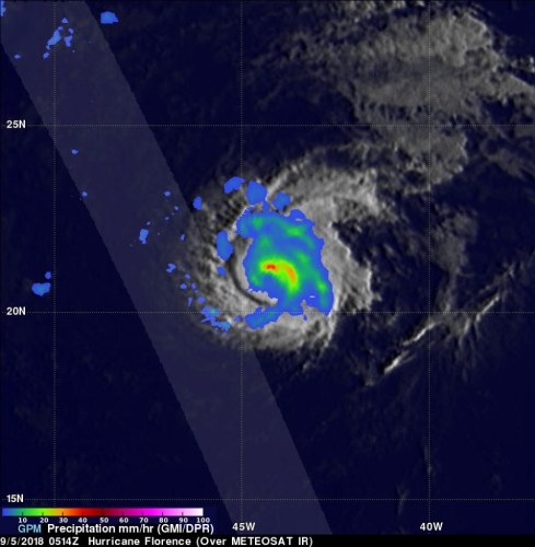
The Global Precipitation Measurement mission or GPM core observatory satellite passed over hurricane Florence on Sept. 5, 2018 at 1:14 a.m. EDT (0514 UTC). Data collected by the GPM satellite’s Microwave Imager (GMI) instruments showed the intensity and location of precipitation around the center of the hurricane. GPM’s GMI revealed that storms north of Florence’s eye were producing heavy rainfall a rate of 50 mm/2 inches per hour. The GPM satellite’s Dual-Frequency Precipitation Radar (DPR) only scanned the nearly rain-free areas to the west of the hurricane.
At NASA’s Goddard Space Flight Center in Greenbelt, Md. a 3D animation was created that showed the estimated heights of storms within hurricane Florence at the time of the GPM satellite pass. Heights are based on data observed by GPM’s radar (DPR Ku Band) blended with estimates from geostationary satellite cloud top temperatures. GPM is a joint mission between NASA and the Japan Aerospace Exploration Agency, JAXA.
On Sept. 15, GPM revealed that storms north of Florence’s eye were producing heavy rainfall. The GPM satellite’s Dual-Frequency Precipitation Radar (DPR) scanned the nearly rain-free areas to the west of the hurricane. Credit: NASA/JAXA, Hal Pierce
At 5 a.m. EDT, the National Hurricane Center noted that Florence was weakening, although still a hurricane. It was centered near latitude 24.1 degrees north and longitude 47.9 degrees west. That’s about 1,060 miles (1,705 km) east-northeast of the Northern Leeward Islands and about 1,170 miles (1,885 km) east-southeast of Bermuda.
Florence is moving toward the northwest near 12 mph (19 kph). NHC forecasters said a turn toward the west-northwest with a decrease in forward speed is expected later today, followed by a turn toward the west by the weekend. Maximum sustained winds have decreased to near 115 mph (185 kph) with higher gusts. Florence is a category 3 hurricane on the Saffir-Simpson Hurricane Wind Scale. Some additional weakening is forecast today, but Florence is expected to remain a strong hurricane for the next several days.
Although still quite a distance from Bermuda, ocean swells generated by Florence will begin to affect Bermuda on Friday and will reach portions of the U.S. East Coast over the weekend. These swells are likely to cause life-threatening surf and rip current conditions.
Hurricane Florence is being steered toward the northwest by the Atlantic subtropical ridge. Early next week the National Hurricane Center (NHC) predicts that hurricane Florence will have moved to a location southeast of Bermuda. Interests in Bermuda should watch the progression of the storm.
For updates on Florence, visit: www.nhc.noaa.gov
Source: www.nasa.gov


