


By Alex Sosnowski,
Senior Meteorologist AccuWeather.com
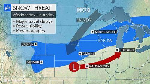
AccuWeather Global Weather Center-(ENEWSPF)- AccuWeather reports a storm will spread a swath of snow from Colorado to Michigan with the potential for blizzard conditions in part of the north-central United States this week.
As a storm pushes east of the Rockies, it will strengthen, gathering wind and moisture by the middle of the week. Like many strong March storms, this system will be multifaceted.
Severe thunderstorms and heavy rain will develop in the storm’s warm sector, while snow falls in the colder air.
Cities that are likely to receive accumulating snow from the storm include Denver; Cheyenne, Wyoming; Omaha, Nebraska; Mason City, Iowa; Minneapolis and Rochester, Minnesota; Green Bay, Wisconsin; and Alpena, Michigan.
Portions of major highways that are likely to be affected by snow and/or wind include Interstate 25, I-35, I-39, I-43, I-70, I-75, I-80, I-90 and I-94.
Airline passengers should be prepared for delays, especially those with connecting flights to and from secondary airports in the swath of heavy snow. It is possible that some crews and aircraft may be displaced due to the magnitude of the storm.
“The heaviest snow is likely to fall from central Nebraska through northern Iowa, central Wisconsin and northern Michigan, where 6-12 inches may fall,” according to AccuWeather Meteorologist Steve Travis.
As the storm strengthens, blizzard conditions will develop over the central Plains. Enough blowing and drifting snow with low visibility can occur to make travel difficult and dangerous for motorists.

“Blizzard conditions will first develop over portions of Colorado, Nebraska and Iowa on Wednesday, then shift northeastward across parts of Wisconsin and northern Michigan on Thursday,” Travis said.
Gusts in part of the snow area, as well as ahead of the storm and immediately in its wake, will range between 40 and 50 mph. The winds will be strong enough to cause sporadic power outages and create difficulties for drivers of high-profile vehicles.
The exact track and strength of the storm will determine the extent of the wintry conditions.
A shift in storm track by 100 miles could bring significant snow instead of drenching rain to Kansas City, Missouri; Chicago; Des Moines, Iowa; Milwaukee and Detroit. These areas will be near the boundary between 60- to 70-degree-Fahrenheit air to the south and 20- to 30-degree air to the north. A wintry mix will occur along part of this swath.
The next stop for the snowstorm and wintry mix will be portions of central and southern Ontario and Quebec, and perhaps northern New York state and New England late in the week.
AccuWeather will continue to provide updates on the storm through this week.


