


By Faith Eherts,
Meteorologist for AccuWeather.com
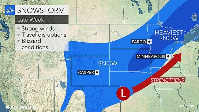
AccuWeather-(ENEWSPF)- AccuWeather reports a strengthening storm will bring the first significant snowfall of the season to the northern Plains with localized blizzard conditions through Friday.
The storm dropped accumulating snowfall across interior portions of the West on Wednesday and Wednesday night.
Strong winds to whip central US
As the storm emerges from the Rockies on Thursday, it will strengthen and gather wind.
Gusts in some areas of the High Plains are expected to exceed 60 mph on Thursday and Friday.
Winds of this strength will have the potential to cause sporadic power outages, minor property damage and travel difficulties.
Gusty winds over dry brush in the central and southern Plains will also raise the risk of wildfire ignition.
n these areas, record highs will be challenged as temperatures climb well into the 70s to the lower 80s F, or 20 to 30 degrees above normal.
Snow, blizzard conditions, to make travel difficult over northern Plains
As the storm taps colder air, an area of heavy, wind-swept snow will break out and expand across the northern Plains prior to the end of the week.
The greatest amount of snow will be on elevated, non-paved surfaces. However, travel conditions will deteriorate quickly due to accumulating snow on roads and sidewalks.
Initially, snow may struggle to accumulate on paved surfaces, due to the recent warmth. As the rate of snow increases, roads will transition from wet to slushy to snow-covered in a short amount of time.
Accumulating snow will expand from eastern Wyoming and northwestern Nebraska to Minnesota and a large part of Northwest Ontario through Friday. Travel is likely to become difficult along portions of Interstate 90 and I-94.
The heaviest band of snow is expected to stretch from central and eastern South Dakota to northern Minnesota and north of Lake Superior in Ontario. Snow in parts of this swath may reach or exceed 12 inches (30 cm).
There will be a sharp variation in snowfall on the northern and southern fringes, where a few miles may mean the difference between a couple inches of snow and over half a foot.
Is there a warming center in Park Forest?
Areas as far south as Denver will have the first flakes of the season late on Thursday with 1-3 inches falling Thursday night. Should snow not occur with this storm, a record could be set. The latest in the season for measurable snow (0.1 of an inch or more) was on Nov. 21, 1934, when 1 inch of snow fell.
Midweek storm to bring first significant snowfall of season to western US
The combination of wind and blowing snow will result in poor visibility and dangerous travel.
“The combination of snow and strong winds could lead to blizzard conditions across portions of Nebraska, the Dakotas and Minnesota,” AccuWeather Meteorologist Brett Rathbun said.
Cold air to plunge in storm’s wake
Behind the storm, temperatures are set to plummet. The weather will be particularly crisp as gusty winds continue, making the air feel much colder than the actual temperature.
“AccuWeather RealFeel® Temperatures will only be in the single digits and teens across the Dakotas on Friday,” Rathbun said.
A quick blast of colder weather will sweep southeastward across the Midwest this weekend.
Temperatures will be slashed by 25-50 degrees Fahrenheit from Minneapolis to Chicago, Detroit and Cincinnati in about 24 hours.


