


Alex Sosnowski,
Senior Meteorologist for AccuWeather.com
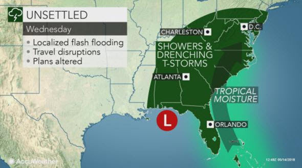
AccuWeather-(ENEWSPF)- AccuWeather reports drenching downpours, gusty winds and strong thunderstorms from a storm that originated from the tropics will affect Florida this week.
The storm only has until the middle of week to acquire some tropical characteristics, so development to a strong tropical storm or hurricane is unlikely, according to AccuWeather Hurricane Expert Dan Kottlowski.
“Water temperatures are marginal for development, but it is possible the system becomes a subtropical depression or storm if it creates a well-defined and strong enough wind field,” Kottlowski said.
Alberto is the first name on the list of tropical and subtropical storms for the 2018 Atlantic hurricane season.
Regardless of gathering a name or not, the storm will cause heavy rain and thunderstorms to expand northward.
Steering winds will guide the storm northward over the eastern Gulf of Mexico, just off the Florida west coast into Wednesday. The storm is projected to move inland along the Florida Panhandle sometime on Wednesday.
It could meander as far to the west as the Alabama and Florida border before taking a gradual curved path to the northeast over the eastern United States later this week.
Drought-busting rain to come at a price
There is the likelihood of both flash flooding and beneficial rain from the storm over Florida.
Rainfall rates of 2 inches per hour are possible in some communities. Localized rainfall may top 6 inches from Monday through this weekend. During this past weekend parts of South Florida have already received between 1 and 4 inches of rain from the storm.
Rainfall directly associated with the storm is forecast to spread over the Southeastern states through Tuesday. During the middle and latter part of the week, the tropical downpours will join up with other showers and thunderstorms across the mid-Atlantic and Ohio Valley.
Motorists and property owners should be prepared to take action where rainfall results in flash flooding.
Motorists should seek an alternative route over higher ground. People in flood-prone areas should closely monitor small streams and storm drains in their neighborhoods for rapid rises in water levels.
Pockets of moderate to severe drought exist in South Florida and in southern Georgia and South Carolina. In these areas, the storm has the potential to end that drought.
In addition to flooding, other hazards from the storm will be isolated severe weather. Some of the strongest thunderstorms may produce a brief tornado or waterspout.
People spending time outdoors should seek shelter at the first sign of an approaching thunderstorm.
The circulation from the large storm will also create stiff winds and rough surf in coastal areas. Until the storm moves well inland later this week, there will be locally strong rip currents and the chance of minor coastal flooding.
After the initial surge of showers and thunderstorms during the first part of this week, downpours will become more sporadic during the second half of the week across Florida. However, showers and thunderstorms will still be likely on a daily basis over much of the state through this weekend.
While the downpours will cool the air slightly, tropical air will create very humid conditions across the state.
There is the potential for a second storm to spring up and move northward from the western Caribbean next weekend into the following week.


